Its 6 AM. and time to take my dogs for a walk. I open my front door and immediately smell the beautiful red and pink roses growing in my front gsrden. They are in full bloom together the giant orange poppies that have been in the gsrden ever since I moved in and long before.

I turn on to the main road Hempstead Valley Drive and walk the short walk to Hempstead Road passing the freshly cut grass along the side of the road and down the bank. Turning right into Hempstead Road towards Rainham, I walk past the many houses and bungalows with their manicured lawns and floral gardens. Most of the residents are still in bed but the odd car is beginning to pass me with the drivers on their way to work.
 The dogs are getting excited here because this is where I cross over Star Lane, opposite the entrance to Spekes Raod and turn left into the woods at the bottom of The Darland Banks I can let them off their leads here. Following the path through the woods I can smell the scent of nettles and other woodland plants I gradually climb to the top of the banks.

I am now at the top of the banks walking West towards Chatham. I have the top woods to my right and, on my left, the steep banks where as a kid I used to either roll down or slide down to Star Lane running along the bottom.

 Carrying along the path, I come to a clearing with a seat where I can sit and take in the view. To the West I can see Chatham and beyond, to the South I can see Bluebell hill and looking back I can see Hempstead. I can see yellow Rape fields and green Wheat fields and trees for miles and miles. I can hear all kinds of woodland birds, Jays and Magpies with their strange cackling sound, I can hear the drum of a Green Woodpecker and then suddenly its wierd screech, I think Kentish People call these Yaffle birds because of the sound that they make. I hear the flutter of Wood pigeons scuffling in the trees, Oak, Elm, Sycamore and several more. I see Crows doing their aerobatics and diving into the grassy banks. Suddenly a Fox breaks cover and runs down the banks and disappears into the Bean field at the bottom. Rabbits scurry to their burrows. There are hundreds of rabbits here as it is a nature reserve now and they are protected but years ago I used to come here with a friend who had Ferrets and we used to go home with loads of Rabbits .


It occurs to me that people such as Normans, Saxons, Romans Etc must have taken this same route to Rochester and London and looked across the same hills. Maybe more forest then but basically the same.

I carry on walking passing some fellow early morning dog walkers and come to the a break in the banks where Star Lane cuts through. If I crossed Star Lane I can enter into the second part of the Darlands leading me to Ash Tree Lane. However, I turn left into Star Lane. There are no vehicles allowed in this part, just the odd bicycle.( When I was young the Star Lane was open to cars all the way from Hempstead Road to where it reaches the A2 at Gillingham)

Walking down Star Lane towards Hempstead I pass through a tunnels of trees and chalky banks . I reach the beautiful old Oast House on my left, what tales this place could tell you. I have known it have several owners and indeed a few years ago it was a restaurant where I would often go to eat. It is now a private residence though and the owner recently had it refurbished.

I carry on past the two white cottages on my right. These cottages belong to the surrounding farm. The farm used to be owned by Mrs Bachelor who died a couple of years ago. A friend of mine who lived in one of these cottages told me that it was the lowest point of Hempstead. The traffic is allowed from Hempstead to this point so the dogs are put back on their leads.

 I carry on along the road passing open fields at the bottom of the the Darlands the farmer has planted beans this year but he rotates his crop yearly sometimes Wheat saometimes Rape. If I look to my left, I can see the banks stretching all the way from Hempstead to Chatham.

Finally I come to the end of Star Lane where it reaches Hempstead Road. I turn right here and re trace my steps back to my house in Hickory Dell.

The journey has taken me about an hour and I suppose I have walked three miles or so.

Many people ask me why I came back to England from Australia, perhaps here lies the answer


Rainham Streets Through The Years

  • Old Photos of Smallholders Club Wigmore Rainham Kent

    Old Photos of Smallholders Club Springvale, Wigmore,  Woodside/Springvale. Smallholders club was one of the first premises in Rainham to have a telephone and the telephone number for the Smallholders club in Wigmore is listed here.  The phone number was Rainham 41 Wigmore & District Smallholders Club Springvale although by 1924 this was already 16 years after the first phone directory for Rainham was published that had 17 telephone numbers listed for local businesses and houses.      2 Springvale, Gillingham Kent ME8 0JG 01634 263408
  • Pictures of Woodside Road, Wigmore

    Old Photos of Woodside originally known as Woodside Road, Wigmore, Gillingham Kent in 1916 Old Photos of  Woodside Wigmore in 1974 Old Photos of  Woodside Wigmore in 2001 Woodside Hoath Lane junction approx 1920 Woodside junction with Hoath Lane in 2003  
  • Old Photos of Station Road Rainham Kent

    These photos of Station Road Rainham Kent have been taken over the last 100 years or so at different locations along the road. Ye Old White Horse Pub Station Road Rainham Kent approx 1900, looking down Station Road with National School on left White Horse pub looking down Station Road approx 1972 Prestige Launderette, Station Road approx 1972 Railway Pub, Station Road, approx 2003 The Railway Hotel, approx 1900 The Railway Hotel Pub, approx 1981   Station Road looking towards Cricketers Pub Station Road looking towards Station, school on left hand side, W&R Fletcher shop in foreground Photos of Station Road Rainham Kent 1996 with Methodist church on right Photo of Station Road Rainham Kent 1996 looking towards Rainham station with Caversham Close under construction View looking up Station road from below level crossing towards Macklands Arms pub, approx 1990   Looking towards Rainham station, Johnsons Ironmongers on the left in distance, Macklands Arms on the right, photo around 1995   Old Photos of Station Road Rainham Kent 2003  
  • Old Photos of High Street Rainham Kent

      High Street Rainham around 1895 with pub Waterman's Arms on left hand side (Truman Hanbury) Rainham High Street c 1910 Photo of Rainham High Street around 1913 showing Lion Hotel (now Green Lion pub) on right hand side Old Photo of High Street Rainham Kent in 1950 showing Barclays Bank on corner of Station Road and prior to Rainham's Coronation Clock being installed   Same location on High Street Rainham Kent but taken in the snow of 1987  
  • Bygone Old Photos of Marshall Road Rainham Kent

    These old photos of 87 Marshall Road Rainham Kent were taken around 1928 and 1932. The huge pile of flints has decreased a bit between the photos. One of the interesting things in the deeds for our house is a covenant that prevents us from selling flints from the house. I wonder if it was a common issue with building at that time and the ground having so many flints in it. You can read about the history of the Rainham Mark Building estate - Edwin Road & Marshall Road here   Above, 87 Marshall Road in 1928        Above, Marshall Road in 1932. You can see a conservatory has been added at this point and the fascia boards have been painted black but the paint on the walls is looking somewhat tired.  The photos below were taken in the late 1980s when the house at 33 Marshall Road was demolished to construct the Charlotte Drive estate
  • Old Photos of Berengrave Lane Rainham Kent

    These are various old Photos of Berengrave Lane Rainham Kent taken at different points over the last 100 years Berengrave/Berengrove House prior to demolition
  • Old Photos of Rock Avenue Gillingham Kent

    Old Photos of number 22 (Waverley House), Rock Avenue Gillingham Kent in 1926 compared to how it looks now in 2011. This was my great grandfather Arthur Percy Light's house who died in the First World war. http://www.everymanremembered.org/profiles/soldier/3049489/ And this is how the same house looks in 2011 via Google Maps. From the condition of the paint on the upstairs roof it looks like it might not have been repainted since 1926!  Photo below of Light family to the rear of 22 Rock Avenue Gillingham Kent Marion, Harold, Beryl Light and Marion Hudson (seated)   View Larger Map View Larger Map
  • Old Photos of London Road Rainham Mark Kent

    These are Old Photos of London Road Rainham Mark Kent taken in the last century along with some more recent photos showing latest changes along the A2 at Rainham Mark. The Co-op was replaced by Town and Country Cars which is now Hidsons. The Belisha Beacon became the Hop and Vine pub which is now Dominos Pizza. Old Photos of London Road Rainham Mark Kent approx 1930. Sngn on building says "Esi-Run Villas Show home open £395" Old Photos of London Road Rainham Mark Kent 2003 showing Hop & Vine pub and Town & Country car dealers   Old Photos of London Road Rainham Mark Kent 2003 showing Hop & Vine pub and Texaco garage  
  • Old Photos of Bredhurst Road Wigmore Gillingham Kent

    Old Photos of Bredhurst Road Wigmore Gillingham Kent. This photo was taken in approx 1920 Photo taken at approximately the same spot in 2003  
  • Old Photos of Ivy Street Rainham Kent

    This old photo of Ivy Street Rainham Kent showing WE Jones Ivy Street Rainham - Woodhams Ales and Stouts was probably taken around 1915   This photo of Ivy Street Rainham towards the River Medway was taken in 2001 in a similar location to the shot above
  • Old Pictures of Historic Hempstead kent

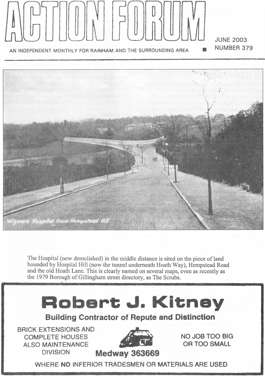
    Pictures of historic hempstead kent. This photo is of Hempstead Hill looking towards the site of the old smallpox isolation hospital situated off Hoath Lane Wigmore. This photo was taken prior to the building of the A278 Link road to join the A2 to the M2 at junction 4 and appears to show that the road splits at the bottom of Hempstead Hill near Spekes Road and goes in the direction of Hoath Lane and Woodside as well as towards Darland Banks/Gillingham. The road now only goes to the left towards Darland Banks and the right hand fork is a tunnel under the A278 Hoath Way nicknamed the Love Tunnel. The buildings above the junction are the Smallpox Isolation hospital, named in the photo as Wigmore Hospital. Hempstead Valley shopping centre shortly after construction in 1978
  • Construction of The Goldings Rainham 1980

    The estate comprising of The Goldings and The Platters off Marshall Road was built from around 1979. These are some photos taken of the construction of the Goldings/Platters Farm estate from Marshall Road in 1980. During the building work several Dene holes were discovered which delayed the construction to excavate and then to fill the holes for houses to safely be built. View Larger Map
  • Where was Broadwalk Rainham?

    These are old photo of Broad Walk Rainham which is now High Street/A2. Broadwalk was the section of the A2 between Rainham Watling Street junction of Mierscourt Road and Otterham Quay Lane and is currently where the Rose Inn and the Congregational Church are located. I believe the houses in the photo below no longer exist. From Kelly's Directory it appears that Broadwalk was renamed High Street in the 1930s along with other street name changes in Rainham. How Rainham Kent Street Names have changed over the years I believe the houses above are the ones in the photo below to the left of the Chapel  
  • Old Photo of Moor Street / High Street Rainham Kent

    This is an old photo of Moor Street Rainham, taken in approx 1910 The same Moor Street location in 2014  
  • Reads Terrace Orchard Street Rainham

    Many of the older houses in Rainham and elsewhere were given names for various blocks of houses. One set of houses in Orchard Street Rainham is known as Reads Terrace and is shown as being built in 1887. This is shortly after Providence Chapel further down Orchard Street was built in 1884 There is still a sign on the Reads Terrace houses showing the name and date of consrtuction
  • Photos of Orchard Street Rainham - Then and Now

    Even in recent timeframes the local area has changed significantly and one example is Orchard Street. I believe land was retained to allow for a bypass to be built avoiding the centre of Rainham but when this plan was cancelled the land was then redeveloped. The photo below from 2001 looking towards Rainham shows the old Lukehurst warehouse with the green wall and corrugated tin roof and car sales yard before the site was cleared to build the new flats Looking up Orchard Street towards Thames Avenue, 2001   Below: Looking towards Rainham with the cleared site after Lukehursts warehouse demolished showing view through to church and Millennium centre Below: Site after Lukehursts warehouse demolished showing view through to church and Millennium centre  Below: Orchard Street Car sales site looking towards school Below: Same location photo of new houses built on Orchard Car sales site, 2003   Providence Chapel Orchard Street, 2001 Orchard Street outside St Margarets School, 2001 New houses, 2003 Former Church Hall site, now flats on Hurst Close/Orchard Street   These photos of Orchard Street Rainham were taken in around 2002 before the bypass land was released and the new housing was built on the former Orchard Street Car Sales and Lukehursts green warehouse    Photos below of Orchard Street during winter of 1987 kindly provided by Darren H
  • Brown Street VE Day Party Photo May1945

    This is a photo of the Brown Street VE (Victory in Europe) Day Party from May 1945
  • Thames Avenue Rainham Old Photos

    This old photo of Thames Avenue Rainham was taken on VE Day in 1945
  • Herbert Road Rainham Old Photos

    Herbert Road Rainham Old Photos - photo of Coronation Party 1952
  • Lonsdale Drive Rainham 1976 - Parkwood Estate

    This photo is of Lonsdale Drive Rainham looking towards cherry orchards (hence the name of Cherry Tree Road nearby) and showing the same scene after building. You can see the same tree on the horizon to get an idea of perspective and position.
  • Marshall Road Rainham Snow in Winter 1987

    The winter of 1987 was particularly hard with some very heavy snowfall that cut off parts of Kent for a number of days due to the roads becoming blocked. These photos of Marshall Road Rainham Kent show the height of the snow at the front door as well as the cars and roads buried underneath the volume of snow that fell.
  • Church House, High Street, Rainham Kent

    Church House, on the right of this view of Rainham High Street from about one hundred years ago, had been the home of the Dodd family, and later Mr Seymour Wakeley, before it was requisitioned during the Second World War as a club for forces personnel stationed in this area. The house was demolished in the early 1960s and for many years the site was derelict. lt is now occupied by the Healthy Living Centre and all that remains of Church House is the palm tree which grew in the garden. This is one of the pictures in ‘A Third Picture Book of Rainham‘ available from Sunburst Books, 21 Station Road  
  • Rainham High Street 1963 showing Coningsby House

    This fascinating photo of Rainham High Street taken in 1963 was kindly provided by Joe Ennis and is one I've not seen before. There are some notable landmarks visible in the photo. Firstly on the left hand side there is a large house at 69 High Street that was called Coningsby House and a forge that was demolished to make way for Rainham Shopping centre. The shops that are now Nutmegs and Greyfox Estate agents are visible on the left of the picture.  On the right hand side you can see the road sign for Orchard Street showing that the Natwest bank was not built at this time. Next to that is the Royal Cinema known as the Bug Hutch - read more here about the Bug Hutch Rainham - Royal Cinema There is a lorry with the words Fremlins County Ale on the front passing by the cinema. You can see Estate agents sign in the distance which would be Harris & Bone   A slightly earlier photo of Rainham High Street looking in the opposite direction gives an idea of the area covered by the picture above. The house now demolished is surrounded by trees in front of it towards the top left of the image.