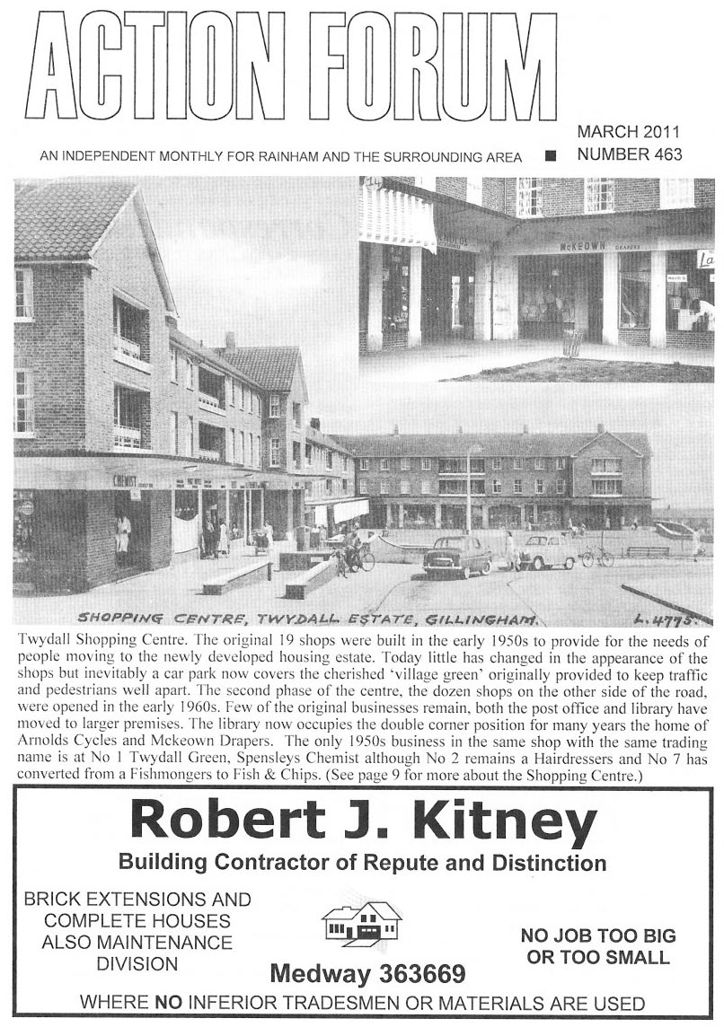
We moved to Lyminge Close, Twydall in 1960 from our wartime built pre-fab in Wigmore when I was 15 months old. Pictured are the 'modern' post war shops but there was also an older red-brick parade opposite. Out of shot on the right of the picture was 'Perks' a dry goods grocers where Mum would buy flour, rice - all sold loose from large wooden bins and served in paper cones expertly folded up from sheets on the counter by the shopkeeper. Even further up on the corner was Cross's the butchers. Well known for being sour faced and sarcastic, Cross was one of three butchers in Twydall; now a dying breed.

Opposite in the older parade was a wet fish shop which became a chippy at night, the library, the Copper Kettle Tea Room/Corner Shop and my favourite place in the world - Arnold's. Tucked away in the far corner, along from the C.K., they sold toys, hundreds of them. It was cheek by Jowl with a milliners and when Mum shopped for her stuff, I was allowed to stand outside and press my nose against Arnold's window. Back on the side pictured, there was a Rumbelows at the lower end for TV's, Radiograms and the booming 45rpm single market. Far left, beyond the bottom of the parade was the good old Royal Engineer. Was there ever a night when there wasn't a fight there? In later years we would spend a pleasant hour or two dodging glasses and combatants while drinking their overpriced Stella Artois (nothing is new) which was then a novelty - 1970's pubs would barely have one lager pump among all the bitters and milds, the Engineer had two.

Twydall Kent in 1960s

The gap between the pub and the first shop pictured (waste land for many years) would be filled before the end of the 60's with a Liptons, for many of us the first Supermarket we'd ever seen. Forbouys was the newsagents who in the 1960's had Jambouree Bags with cheap sweets and toys, but also a 'Lucky Dip' a thin wooden flour barrel filled with sawdust. You paid 3d (1p!) and dove your hand into the barrel and grabbed one item. It would be anything from a Barrats Sherbert fountain, to a plastic toy. Next door was Woolworths (Woolies) which in those days still had the wooden floor, the island counters and the ubiquitous weighing machine at the door. Mum worked there as did (eventually) I on Saturdays but by then, a more modern Woolies had developed.

Ice cream would be bought in blocks, wrapped in newspaper to be taken home, every week the rag'n'bone man would come up our Close - like Steptoe and Son with a horse drawn cart. The onion seller would bring a cycle laden with huge onions, and on another day the peanut and toffee apple man would be there as well, also with everything on a bike. Developments over the years included the oddly shaped Holy Trinity Church built on wasteland land I used to play on. The lovely green area we played football on the right by the library was paved over to become a car park, and the doctor's surgery opposite the Church. For school we'd walk up Twydall Lane in the direction of the now defunct Bowaters and head into the infants, until we were 7 and had to go a little further up to Romany Road Primary which would take us past Tabearts. They sold just about everything, but the attraction for us kids was that he had rows and rows of sweets in Jars, sold by the quarter pound (100g in new money); I still remember the sweet smell in the shop of all that sugar just waiting to be bought.

Public transport in the 1960's defied modern belief. Twydall was served by at least three separate but related Maidstone and District (M&D) bus routes which ran to and from the Nelson Road Bus Depot. All would run along Beechings Way past the Golf course. The No. 1 and 1A, would turn up Eastcourt Lane, while the 1B continued down Beechings Way ending up at the bottom of Pump Lane. The other two turned along Goudhurst Road with the 1A following it past the shops at the bottom and turning round the bend to meet Beechings Way again, where it would turn back. Only the No. 1 would go up past the shops turning left along Waltham Road (lined on one side with police houses) on down Begonia Avenue to Hawthorne Road. All were double deckers with Clippies, but unlike the London routemasters the buses had closed rear decks. These days everyone uses their car, but then no-one had cars. Those buses were full; bottom and (hideously, smoking permitted) upper decks. Lyminge Close had a small parking area, which would hold 6 or so cars, the rest given over to play areas where football matches resembling the 'Wall Game' would sweep back and forth all afternoon.

I last visited a year or so back, and some 20 cars seemed to be parked in an enlarged area which encroached on virtually all the grass, with all the kids probably inside with their PS3's. Our play rules were simple, we left after breakfast with a cheese sandwich in our pocket and were home before dark. We either headed 'down' to Sharps Green, or 'Up' to the Darland Banks (which were north and south respectively) crossing the lethal Watling Street (A2) in the process. Somehow we all survived to be flabby and fifty.

I left Twydall in the mid 70s and travelled and lived at odd spots in and around the world before settling back in Sussex, about 70 miles away. On the few occasions I've been back though it feels further. I watched England win the World Cup, both Kennedy's and MLK get assassinated, and Neil Armstrong walk on the moon while living there, no wonder my memories are rooted firmly in the turbulent 1960s. 


Rainham Streets Through The Years

  • Old Photos of Smallholders Club Wigmore Rainham Kent

    Old Photos of Smallholders Club Springvale, Wigmore,  Woodside/Springvale. Smallholders club was one of the first premises in Rainham to have a telephone and the telephone number for the Smallholders club in Wigmore is listed here.  The phone number was Rainham 41 Wigmore & District Smallholders Club Springvale although by 1924 this was already 16 years after the first phone directory for Rainham was published that had 17 telephone numbers listed for local businesses and houses.      2 Springvale, Gillingham Kent ME8 0JG 01634 263408
  • Pictures of Woodside Road, Wigmore

    Old Photos of Woodside originally known as Woodside Road, Wigmore, Gillingham Kent in 1916 Old Photos of  Woodside Wigmore in 1974 Old Photos of  Woodside Wigmore in 2001 Woodside Hoath Lane junction approx 1920 Woodside junction with Hoath Lane in 2003  
  • Old Photos of Station Road Rainham Kent

    These photos of Station Road Rainham Kent have been taken over the last 100 years or so at different locations along the road. Ye Old White Horse Pub Station Road Rainham Kent approx 1900, looking down Station Road with National School on left White Horse pub looking down Station Road approx 1972 Prestige Launderette, Station Road approx 1972 Railway Pub, Station Road, approx 2003 The Railway Hotel, approx 1900 The Railway Hotel Pub, approx 1981   Station Road looking towards Cricketers Pub Station Road looking towards Station, school on left hand side, W&R Fletcher shop in foreground Photos of Station Road Rainham Kent 1996 with Methodist church on right Photo of Station Road Rainham Kent 1996 looking towards Rainham station with Caversham Close under construction View looking up Station road from below level crossing towards Macklands Arms pub, approx 1990   Looking towards Rainham station, Johnsons Ironmongers on the left in distance, Macklands Arms on the right, photo around 1995   Old Photos of Station Road Rainham Kent 2003  
  • Old Photos of High Street Rainham Kent

      High Street Rainham around 1895 with pub Waterman's Arms on left hand side (Truman Hanbury) Rainham High Street c 1910 Photo of Rainham High Street around 1913 showing Lion Hotel (now Green Lion pub) on right hand side Old Photo of High Street Rainham Kent in 1950 showing Barclays Bank on corner of Station Road and prior to Rainham's Coronation Clock being installed   Same location on High Street Rainham Kent but taken in the snow of 1987  
  • Bygone Old Photos of Marshall Road Rainham Kent

    These old photos of 87 Marshall Road Rainham Kent were taken around 1928 and 1932. The huge pile of flints has decreased a bit between the photos. One of the interesting things in the deeds for our house is a covenant that prevents us from selling flints from the house. I wonder if it was a common issue with building at that time and the ground having so many flints in it. You can read about the history of the Rainham Mark Building estate - Edwin Road & Marshall Road here   Above, 87 Marshall Road in 1928        Above, Marshall Road in 1932. You can see a conservatory has been added at this point and the fascia boards have been painted black but the paint on the walls is looking somewhat tired.  The photos below were taken in the late 1980s when the house at 33 Marshall Road was demolished to construct the Charlotte Drive estate
  • Old Photos of Berengrave Lane Rainham Kent

    These are various old Photos of Berengrave Lane Rainham Kent taken at different points over the last 100 years Berengrave/Berengrove House prior to demolition
  • Old Photos of Rock Avenue Gillingham Kent

    Old Photos of number 22 (Waverley House), Rock Avenue Gillingham Kent in 1926 compared to how it looks now in 2011. This was my great grandfather Arthur Percy Light's house who died in the First World war. http://www.everymanremembered.org/profiles/soldier/3049489/ And this is how the same house looks in 2011 via Google Maps. From the condition of the paint on the upstairs roof it looks like it might not have been repainted since 1926!  Photo below of Light family to the rear of 22 Rock Avenue Gillingham Kent Marion, Harold, Beryl Light and Marion Hudson (seated)   View Larger Map View Larger Map
  • Old Photos of London Road Rainham Mark Kent

    These are Old Photos of London Road Rainham Mark Kent taken in the last century along with some more recent photos showing latest changes along the A2 at Rainham Mark. The Co-op was replaced by Town and Country Cars which is now Hidsons. The Belisha Beacon became the Hop and Vine pub which is now Dominos Pizza. Old Photos of London Road Rainham Mark Kent approx 1930. Sngn on building says "Esi-Run Villas Show home open £395" Old Photos of London Road Rainham Mark Kent 2003 showing Hop & Vine pub and Town & Country car dealers   Old Photos of London Road Rainham Mark Kent 2003 showing Hop & Vine pub and Texaco garage  
  • Old Photos of Bredhurst Road Wigmore Gillingham Kent

    Old Photos of Bredhurst Road Wigmore Gillingham Kent. This photo was taken in approx 1920 Photo taken at approximately the same spot in 2003  
  • Old Photos of Ivy Street Rainham Kent

    This old photo of Ivy Street Rainham Kent showing WE Jones Ivy Street Rainham - Woodhams Ales and Stouts was probably taken around 1915   This photo of Ivy Street Rainham towards the River Medway was taken in 2001 in a similar location to the shot above
  • Old Pictures of Historic Hempstead kent

    Pictures of historic hempstead kent. This photo is of Hempstead Hill looking towards the site of the old smallpox isolation hospital situated off Hoath Lane Wigmore. This photo was taken prior to the building of the A278 Link road to join the A2 to the M2 at junction 4 and appears to show that the road splits at the bottom of Hempstead Hill near Spekes Road and goes in the direction of Hoath Lane and Woodside as well as towards Darland Banks/Gillingham. The road now only goes to the left towards Darland Banks and the right hand fork is a tunnel under the A278 Hoath Way nicknamed the Love Tunnel. The buildings above the junction are the Smallpox Isolation hospital, named in the photo as Wigmore Hospital. Hempstead Valley shopping centre shortly after construction in 1978
  • Construction of The Goldings Rainham 1980

    The estate comprising of The Goldings and The Platters off Marshall Road was built from around 1979. These are some photos taken of the construction of the Goldings/Platters Farm estate from Marshall Road in 1980. During the building work several Dene holes were discovered which delayed the construction to excavate and then to fill the holes for houses to safely be built. View Larger Map
  • Where was Broadwalk Rainham?

    These are old photo of Broad Walk Rainham which is now High Street/A2. Broadwalk was the section of the A2 between Rainham Watling Street junction of Mierscourt Road and Otterham Quay Lane and is currently where the Rose Inn and the Congregational Church are located. I believe the houses in the photo below no longer exist. From Kelly's Directory it appears that Broadwalk was renamed High Street in the 1930s along with other street name changes in Rainham. How Rainham Kent Street Names have changed over the years I believe the houses above are the ones in the photo below to the left of the Chapel  
  • Old Photo of Moor Street / High Street Rainham Kent

    This is an old photo of Moor Street Rainham, taken in approx 1910 The same Moor Street location in 2014  
  • Reads Terrace Orchard Street Rainham

    Many of the older houses in Rainham and elsewhere were given names for various blocks of houses. One set of houses in Orchard Street Rainham is known as Reads Terrace and is shown as being built in 1887. This is shortly after Providence Chapel further down Orchard Street was built in 1884 There is still a sign on the Reads Terrace houses showing the name and date of consrtuction
  • Photos of Orchard Street Rainham - Then and Now

    Even in recent timeframes the local area has changed significantly and one example is Orchard Street. I believe land was retained to allow for a bypass to be built avoiding the centre of Rainham but when this plan was cancelled the land was then redeveloped. The photo below from 2001 looking towards Rainham shows the old Lukehurst warehouse with the green wall and corrugated tin roof and car sales yard before the site was cleared to build the new flats Looking up Orchard Street towards Thames Avenue, 2001   Below: Looking towards Rainham with the cleared site after Lukehursts warehouse demolished showing view through to church and Millennium centre Below: Site after Lukehursts warehouse demolished showing view through to church and Millennium centre  Below: Orchard Street Car sales site looking towards school Below: Same location photo of new houses built on Orchard Car sales site, 2003   Providence Chapel Orchard Street, 2001 Orchard Street outside St Margarets School, 2001 New houses, 2003 Former Church Hall site, now flats on Hurst Close/Orchard Street   These photos of Orchard Street Rainham were taken in around 2002 before the bypass land was released and the new housing was built on the former Orchard Street Car Sales and Lukehursts green warehouse    Photos below of Orchard Street during winter of 1987 kindly provided by Darren H
  • Brown Street VE Day Party Photo May1945

    This is a photo of the Brown Street VE (Victory in Europe) Day Party from May 1945
  • Thames Avenue Rainham Old Photos

    This old photo of Thames Avenue Rainham was taken on VE Day in 1945
  • Herbert Road Rainham Old Photos

    Herbert Road Rainham Old Photos - photo of Coronation Party 1952
  • Lonsdale Drive Rainham 1976 - Parkwood Estate

    This photo is of Lonsdale Drive Rainham looking towards cherry orchards (hence the name of Cherry Tree Road nearby) and showing the same scene after building. You can see the same tree on the horizon to get an idea of perspective and position.
  • Marshall Road Rainham Snow in Winter 1987

    The winter of 1987 was particularly hard with some very heavy snowfall that cut off parts of Kent for a number of days due to the roads becoming blocked. These photos of Marshall Road Rainham Kent show the height of the snow at the front door as well as the cars and roads buried underneath the volume of snow that fell.
  • Church House, High Street, Rainham Kent

    Church House, on the right of this view of Rainham High Street from about one hundred years ago, had been the home of the Dodd family, and later Mr Seymour Wakeley, before it was requisitioned during the Second World War as a club for forces personnel stationed in this area. The house was demolished in the early 1960s and for many years the site was derelict. lt is now occupied by the Healthy Living Centre and all that remains of Church House is the palm tree which grew in the garden. This is one of the pictures in ‘A Third Picture Book of Rainham‘ available from Sunburst Books, 21 Station Road  
  • Rainham High Street 1963 showing Coningsby House

    This fascinating photo of Rainham High Street taken in 1963 was kindly provided by Joe Ennis and is one I've not seen before. There are some notable landmarks visible in the photo. Firstly on the left hand side there is a large house at 69 High Street that was called Coningsby House and a forge that was demolished to make way for Rainham Shopping centre. The shops that are now Nutmegs and Greyfox Estate agents are visible on the left of the picture.  On the right hand side you can see the road sign for Orchard Street showing that the Natwest bank was not built at this time. Next to that is the Royal Cinema known as the Bug Hutch - read more here about the Bug Hutch Rainham - Royal Cinema There is a lorry with the words Fremlins County Ale on the front passing by the cinema. You can see Estate agents sign in the distance which would be Harris & Bone   A slightly earlier photo of Rainham High Street looking in the opposite direction gives an idea of the area covered by the picture above. The house now demolished is surrounded by trees in front of it towards the top left of the image.