Rainham History - History of Rainham Kent, Old Photos and Life in Bygone Times
THE CHANGING FACE OF RAINHAM Kent (Part 1)
THE CHANGING FACE OF RAINHAM
By Freddie Cooper, Action Forum November 2002
It was encouraging to see so many residents at Joe Ennis’s slide show depicting ‘Old Rainham’ and I was pleased to answer questions afterwards. I wonder if the obvious new interest in the history of our locality is being adequately catered for by present organisations. Many properties have been lost in the High Street and many more are likely to be fundamentally changed or demolished as residential development replaces business premises so I checked with the directory to compare the area depicted in most of the slides around the turn of last century.

The population of Rainham in 1901 was 3,693 (probably around 40,000 for the same area now), employment was mainly in agriculture and brick or cement making, farming was in the doldrums and many residents were very poor as they were not paid for production lost due to inclement weather and most families had many more children than now. It was a make and mend society and few would travel outside of the village for purchases so Rainham shops would have provided every need and there was plenty of competition.
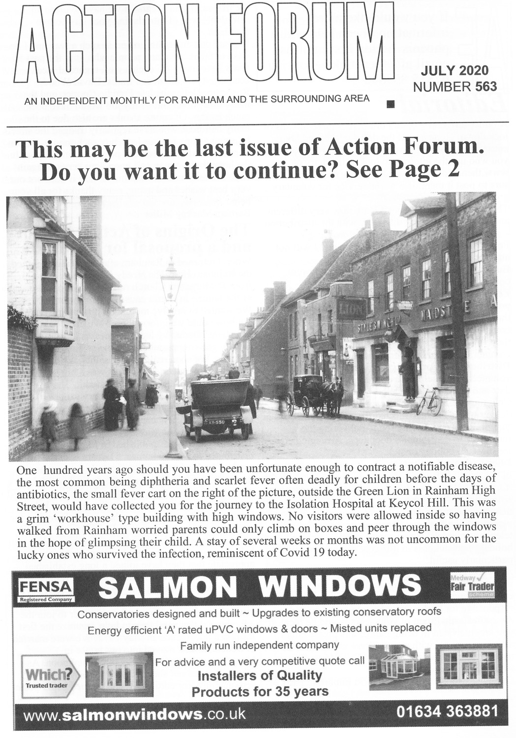
The High Street, going east, started at the Cricketers on one side and The White Horse opposite, all properties to the west were then in London Road and, like many of our roads at that time, neither were numbered so postmen had to quickly learn where everyone lived. The advertisements in Kelly’s Directory of 1908 give, perhaps, the best explanation of life just nine years before I was born and emphasise the origin of two of the most influential inventions of our time.
That for The White Horse quotes telephone number 10 and shows pictures of both a horse drawn charabanc for outings and a brake to transport residents or to collect commercial travellers from the station by appointment. It obviously took advantage of the new motorised travel as in addition to providing ‘Livery and Bait Stabling’ it also had a ‘Motor Garage and Pit’. The proprietor was Mr Charles Adie whose son Leigh succeeded him and I believe that grandson Ron continued later. Prior to the Adie’s Mr Sayer was ‘mine host’ and it was he who, it is said, planted a chestnut tree in front of the Church to commemorate the birth of each of his children.
The Cricketers had no advert in Kelly’s but that in The History of Rainham (Kent) by Edwin Harris published in 1917 was equally interesting. The proprietor Mr C.W. Shaw had taken oVer from Mr Harry Charles Taylor and advertised that it was ‘Home from Home’ and ‘the place to spend a pleasant holiday’. This hostelry also had ‘Stablmg and a Motor Garage’.
Mr Arthur Tucker, two doors down from Pudding Lane, was Watchmaker Jeweller and Optician and he advertised ‘table and pocket cutlery’, with ‘private room specially fitted out with the latest appliances for sight testing’.
Freddie Cooper
THE CHANGING FACE OF RAINHAM Kent (Part 2)
THE CHANGING FACE OF RAINHAM Kent
By Freddie Cooper, from Action Forum, December 2002
Mr William Henry Barling (late W. Rush) was in Manchester House, next to Ivy Street, and sold ‘up to date drapery goods of every description, with a splendid selection of dress materials and curtains’. He was the agent for Frister & Rossmann’s sewing machines and Mortimer Brothers High Class Dyers and Cleaners.

Old photo of Ivy Street, Rainham Kent
George Whayman was on The Banks, almost opposite Ivy Street, an 'Outfitter and Boot Merchant' who sold men’s clothing of every description, ready made or gentlemen’s suits to measure for 24/6d (£1 22 ½p) or trousers for 7/lid (40p). Edwin Jelley nearly opposite at Cheapside on the eastern corner of Pudding Lane also boasted the most up to date stock of reliable clothing with gentlemen’s ready to wear suits at £1. He gave 5% discount for cash and was agent for six stated brands of footwear.
Glass and Son, the family Bakers, were two doors east of Marlborough House and were very popular as pastry cooks and cake manufacturers beside being corn, flour and seed factors with van deliveries to all parts daily. They had their name painted high up on the side wall and I remember buying 2d of stale buns when an aunt told me to wait for lunch.
THE GREEN LION PUBLIC HOUSE was a very busy hostelry being headquarters to The Cycling, Cricket and Football Clubs, The Cottage Gardeners Society, Ancient Order of Foresters and The Court of Anglo Saxons. Like all pubs they had their own Benefit Society which paid members during sickness or upon death with a share out in December. Phil Curling, mine host, was ‘handicapper to all the principal Club and Race meetings in the District’. Professional running and cycling were popular even in the 20s and 30s and I remember seeing Sam Ferris the Olympic long distance runner who had been challenged to compete against a man named Walters from Upchurch.

The Rainham and District Co-operative Society Ltd, with all departments in Station Road, had only recently been formed at the turn of the century but its turnover in 1907 was £16,000 with profit of £1,500 and a membership of 505. Its telephone number is not quoted but I believe it was number 4. There were no multiples except perhaps the Co-op which was owned by the members so the proprietors would know most of their customers and become important personalities within the village. A majority of the shops listed in 1908 were still within the same family ownership 20 or 30 years later.
A business which needed no advertisement locally was that of George Longley, Nurseryman and Florist, then operating from Mardale Nursery in Chapel Lane (now Miers Court Road) and Pond House just west of the present Durland House. Numbers 29 and 31 Miers Court Road still have the name Mardale Nursery 1905 high up on the front. I understand that the family came from Sheldwich in 1819, were founder members of the original English Rose Society in the 1890s and were the only Rainham firm to be granted the Royal Warrant which was exhibited on the front of Pond House. The rose gardens were a wonderful sight adjacent to the railway line between Station Road and Berengrave Lane and later on both sides of the lane below the railway arch. Although some members of the family branched out into farming the present Berengrave Nursery is operated by a direct descendant of those who came to Rainham nearly 200 years ago and I hope to write a separate story in a future issue as the history of the Longley family is very typical of the history of Rainham over the last two centuries.
Freddie Cooper
You can view a list of the businesses with telephones in Rainham in 1908 here
Dene Holes found in Rainham, Kent
Dene Holes found in Rainham, Kent
A number of 'Dene Holes' have been discovered in different locations in the Rainham area. Their true origins are not known, but there is speculation that they may have been chalk mines, underground storage for grain or for shelter from Danish invaders, hence 'Dane holes'. The basic design consists of a narrow shaft cut straight down until it widens into a larger chamber. Their age is uncertain, but some were still being dug around a hundred years ago, while some apparently show marks indicating that they were dug with picks made of bone, supporting the view that in some cases their origin may pre-date the Romans.

A dene hole was discovered in Twydall Lane in 1931 by Mr Harlow. He excavated the site and produced plan of the dene hole shown here. Niches were found at points A and B which were about 9 feet in height but not reaching the surface. These shafts were blackened with smoke so it may be that they were chimneys for torches or fires.
There is still a dene hole that you can see at Capstone Country Park near Hempstead.
In 1980, several dene holes were discovered during the construction of the Platters Farm estate off Marshall Road. The pictures show the dene hole at the junction of The Goldings and The Platters. This was excavated by the builders and refilled prior to construction of the houses, but after the road had been built.
 |
|
 |
 |
| Dene Hole discovered in Rainham Kent, July 1980 | Trench that discovered Dene hole running parallel to road | Dene Hole After Excavation |
The same Dene Hole location
The Goldings/Platters junction facing towards Marshall Road 2004 |


See the following links for more information.
http://47.1911encyclopedia.org/D/DE/DENE_HOLES.htm
http://www.glias.org.uk/news/167news.html#O
http://www.1911encyclopedia.org/Dene-Holes
Details of Dene Holes from "Off The Beaten Track-A Short History of Bredhurst, Wigmore and Hempstead" by Geoffrey Hutton. Published by Meresborough Books 1993, available from Rainham Bookshop.
WATTS THE CHEMIST
WATTS THE CHEMIST , Rainham Kent
Action Forum, July 2002
Among the archives of Watts the Rainham Chemist, whose name can still be read above the boarded-up shop in Rainham High Street, are several books dating back to the mid-nineteenth century. Two contain the notes made by different members of the family as they studied for their pharmacy qualifications. These books both begin with lectures on botany and elementary chemistry, the first page in one case being headed ‘Special Short Notes on Pharmacy. Minor Lecture No. 1’. The lectures, ending with No. 59, are recorded in a soft-back school notebook, but the student’s attention was not always wholly engaged. Beneath the page entitled ‘Lecture 7’, on practical dispensing, is written ‘A lecture far too long, of facts (too) well-known to write’. And inside the back cover the owner has practised the signature ‘R. Watts’ many times. A second, hardback, notebook which is un-named has similar notes on the sante course of lectures, dated 1885, and also includes ‘Practical Notes on Photography’.

Robert Watts was the nephew of Henry Watts, a widower, who had been in business as Chemist and Druggist in Chatham High Street from the mid-nineteenth century. In 1881 Henry had two apprentices, Robert, aged 17, and Frank Dixon, who was 16. Robert stayed with his uncle at the shop near the bottom of Hamond Hill for at least ten years. but by 1899 he had taken over the premises of George Andrew, Chemist and Druggist. They were at No. 126 High Street, Rainham, next to the ‘Waterman’s Arms’, and opposite Ivy Street. For many years a gas lamp standard, with ‘Watts Chemist’ painted on the glass enclosing the light, stood outside. During the early part of the twentieth century Watts also acted as an insurance agent. The heading of a partly-used duplicate book makes it clear that he was now fully qualified: ‘Robert Watts, Dispensing Chemist (by examination)’.
Of more general interest are two volumes in which have been collected recipes for the wide variety of products sold by a Victorian chemist — not just medicines, but ink, fly glue, hair pomades and tonics, ginger beer and lemonade, label varnish, curry powder, Nubian blacking and lavender water. Many of these have been cut from papers and stuck in, others are hand-written. Some have been crossed through, perhaps because a more effective ‘chilblain specific’ or ‘remedy for warts’ has emerged. Medicines for sick dogs, sheep, cows and horses play a significant part. The earliest note dates from 1842, but other hands have continued the collection beyond 1880.

Photo of Watts the Chemist shop in 2001 (centre of the shot with red WATTS on green sign)
This ‘Cure for the Ague’ is never known to fail if taken regularly:
Powder bark
Ground black pepper
Salt
Tartar
Snake root powder
Poppy syrup
Treacle sufficient to form an electualy.
This was to be taken every four hours ‘when the fit is oft’. The compiler remarks that for ‘wealdy wemen and children’ the snake root should be omitted. Also preserved is a counter prescription book, which opens in August 1900, from the Rainham shop At the front is an index of account customers, with details of the medicines which were frequently required by them. Then begins the record of what was dispensed each day, occasionally with marginal notes — ‘heart shaky’; ‘tuberculous glands’; ‘slight sunstroke’. By 1912 prices are sometimes added: 1/-was standard. After this date the book has been used only intermittently; in 1919, in 1922 for a while, then in 1936. About ten prescriptions were dispensed daily, each transaction carefully numbered.
After the 1950s fewer and fewer medicines were mixed on the premises, and the prescriptions read ‘tabs’ of branded products, such as ‘Dequadin loz(enges)’. From 1960 the inclusion of the name of the doctor becomes more frequent, and when the record ends in the early seventies, by which time perhaps 50% of all prescriptions are for ‘the pill’, it is always noted.
According to a street directory of 1954/5 there were by then two other Chemists in Rainham, Fenwick’s at 31 London Road and Hickmott’s at 85 London Road, while Watts remained at the original site. The section of the A2 known as London Road at that time extended as far as ‘The Cricketers’. Watts the Chemist finally closed about twenty years ago, as the trading centre of Rainham moved west and other pharmacies, closer to doctors’ surgeries, flourished.
RAD
How Was Berengrave Lane so named?
HOW WAS BERENGRAVE LANE SO NAMED?
By Freddie Cooper, December 2001
I am fortunate in having some of the notes of the late Mr W.J. Smith, and Mr Stuart L. Jelley who both wrote about the history of Rainham. The former will be remembered by older residents as Headteacher of the Council School in Solomon Road who then took over the new Senior Boys’ School in Orchard Street when it opened in 1933. The latter was a proprietor of a large outfitters shop on the corner of Pudding Road, now the restaurant, whose father Edwin Jelley with Marshall Harvey developed that area of Rainham Mark which bears their names. [note the original article by Freddie refers to Edwin Jelley but the shop photo shows it spelt as Jelly)

In one of Mr Smith’s writings he explained the origin of various place names including Berengrave which he said took its name from the ‘Berens’ family who were well known in Kent. I had no reason to doubt its accuracy until I recently examined a map dated 1801. This was fairly small scale and the roads were not named but the one which continued to the river directly opposite to the one leading to Bredhurst and Wigmore showed a ‘Burying Grave’ about a quarter of the way down the lane and the words spanned both sides of the road. I emphasise that this was small scale but the wording is just south of a ‘link’ to a road which I take to Bloors Lane and presume to be the present pathway.

The rather unusual description may or may not have significance because Roman burial grounds are marked on later maps as ‘Roman Cemeteries’ as is the one just east of the road to Motney Hill where many valuable articles were found, some of which are said to be in Eastgate Museum, Rochester. This was distinctly separate from the seven Roman burial urns found on the Saltings to the north of Rainham Creek between Bartlett Creek and Nor Marsh in January 1881 which contained human remains.
On the other hand, the Manor of Queencourt comprised some 485 acres of arable, pasture and marsh land, much of which was either side of Berengrave Lane, with a water mill beside Rainham Creek ‘at the end of a little lane to the east of Bloor’s Place’, probably now Motney Hill Road. There were about 36 acres in Upchurch and Lower Halstow. With the exception of ‘Berengrave House’ and 30 acres the rest of the property was sold by Mr ‘Squire’ Walter and his sisters to various purchasers in 1900. Berengrave Lane was known to many older residents as Walter’s Lane, and the Squire owned various other properties in Rainham, including The Parsonage. Going back into history the Manor was given by Queen Alianore (sometimes Eleanor) wife of Henry III to the Master and Brethren of St Katharine’s Hospital in 1273. This was to re-establish a charity to support six poor bachelors and six poor spinsters. I do not know if the institution still exists but last century its title was The Royal Hospital and Collegiate Church of St Catherine providing schools for boys and girls, a guild for past scholars, and a chapter consisting of a master, three brothers and three sisters. The Queen’s nurses had a house and offices there.

I’ve strayed somewhat from the origin of the name of ‘Berengrave’ but I have tried to show that this was a very important area somewhat independent of the village, although only four houses are shown as built in the lane up to 1901, a lot of workers must have been employed. The population of Rainham in 1801 was 722. On the other hand I did wonder if a ‘Burying Grave’ might have been placed remote from the village when residents were afraid of infection during the Plague. This seems unlikely in such close proximity to the Manor House but perhaps others may cast light on the subject. So many place names have been corrupted over the years that I can quite easily see how ‘Burying Grave Lane’ became ‘Berengrave’ but I’m afraid that readers must decide!
The present Berengrave Lane is very different from that which I frequented as a young boy in the early 1920s. It was then a very eerie road at night with no pavements, the wind howling through high overgrowing trees and only three single mantle gas lamps from the top down to the railway line. If you reached Berengrave House you’d hear footsteps on crackling brittle dead holly leaves and then suddenly the old donkey would start braying which made an already nervous youngster take off. There was also the popular legend about the headless horseman who galloped down the lane at midnight. If I had known that there was also a Burying Grave lower down I’d have been petrified!

P.S. I have been reminded that some older readers consider that the main house in the Lane should be spelt Berengrove and not Berengrave, so I consulted Mr Peter Sargent at the Map Shop who, having checked with the Ordnance Survey Agency, found that the five maps issued between 1878 and 1933 showed the residence spelt with an ‘a’ but those issued in 1938 and 1959 (just before it was demolished) had an ‘o’. The current map shows the Council ‘plant area’ off Bloor’s Lane as Berengrove Nursery. Cozenton Farm, which was next door to Berengrove? House, was described as Corzenton on the Deeds in 1888 whereas the map of 1891 shows it as Cozenton. There is an area at the bottom of Blue Bell Hill called Cossington which probably had the same origin.
Many roads and place names have been changed over the years, even the village itself has apparently been Rygingaham, Raegingaham, Raenham, Raynham, Reinham, and Renham before getting to Rainham.
Freddie Cooper

The Lord Stanley Pub
Rainham Kent Photos & Information
In a recent issue of Action Forum, there was a query about The Lord Stanley Pub. I have received a number of calls about this and the information received is summarised below.
Bob Barnes' grandfather took over the Lord Stanley in 1913. It was initially a pub and general store, similar to an off licence today. It was located at the bottom of Windmill Hill opposite Otterham Quay caravan site where a new bungalow now stands.
It was converted to a private residence but burnt down around 1980.
A picture of the pub can be found in the Meresborough Books publication, "Photos of Old Rainham", 1983 and also in "Gillingham, Then and Now" by John Guy, 1981,available from Rainham Bookshop.
 |
THE LORD STANLEY Public House Upchurch
THE LORD STANLEY
Action Forum, November 2001
In July a reader asked the editor if anyone knew the correct location of the Lord Stanley, a fair number responded, some were right some wrong. I started a search by visiting Peter Sargent who has recently transferred his Ordnance Survey Map business from Chatham to rooms above the Rainham Bookshop and obtained maps of this area dated back to 1801. I was fortunate enough to have the advice of my neighbour Mrs Ellen Tyler (née Swan) who spent her early life in Caroline Place, a terrace of 16 houses built by Eastwoods for their ‘Brickies’ on the road alongside the Three Sisters PH.
I learned a lot from my studies which I hope to share with readers later but none of this was as persuasive as the picture of the Lord Stanley which by chance I found on page 12 of the Rainham Red Book. This was apparently taken before 1910 as the Mill at the top of Windmill Hill is also in the picture at the bottom of the hill on a site which, I believe, is now occupied by a bungalow and various commercial undertakings. The ‘pub’ eventually became ‘Barnes Shop’ and a Mrs Beryl Shave wrote to explain that her mother, Mrs Minnie Hopper, now 93, was Mr Barnes’ daughter so I was able to ascertain family information at first hand. I was unable to find out when the ‘L.S.’ opened as a licensed house but understand that it was named after a Stanley Wakeley. It closed in 1918 when Mr Barnes opened the shop which subsequently served those living in the fairly isolated areas of Otterham, Upchurch, and Lower Halstow, first by horse and cart and later with a van. Mr Barnes died in 1956 but his daughter Ethel carried on the business until VAT was introduced and left the premises in 1980. The building remained empty for a period before, like the Mill at the hilltop, it was destroyed by fire.
Mrs Tyler also told me about Mr Richens, whose shop next to the Three Sisters PH was already established when Mr Barnes arrived in 1918. He supplied most general needs from meat to oil, in fact like most village ‘butchers’, he had a slaughter house at the top of the garden. We had one within 30 yards of the C of E School at the top of Station Road and our lessons or play were often accompanied by the squeal of pigs. One has to remember that there was a small general store in most roads for the odd daily purchase, we had no refrigerators or freezers and children were often sent for small quantities ‘on the slate’ (payable on pay day). I would presume that Otterham residents would have come by bus or bike to Rainham for their main purchases. Regular rounds by cart or van were made by milkmen, bakers, greengrocers, a fishmonger, and coalmen and, when in season, a shrimp and winkle man on a trandesman’s cycle clanging a bell before Sunday teatime. For those able to purchase fair quantities a boy would call from the International, Quinnells, or Roses on Thursdays for an order book for groceries to be delivered the following day. Although few lived in the immediate vicinity it is an indication of the number employed in the manufacture and distribution of bricks and cement that there were three ‘pubs’ in Otterham Quay around the turn of last century.
In addition to the Lord Stanley and the Three Sisters there was also the Anchor and Hope which was demolished in 1921 and a Working Men’s Club (period of activity unknown but I seem to remember it about 200 yards N.E. of the Three Sisters around the time of the last War). Incidentally the Three Sisters PH and all that side of Otterham Quay is in Upchurch (Swale), the boundary line runs roughly up the centre of the creek. I hope to write more about brick and cement making and barge transportation when Otterham was a hive of industry around the early 1900s in a later issue.
Freddie Cooper
Rainham Mark, Belisha Beacon, Hop and Vine pub
Rainham Mark, Belisha Beacon, Hop and Vine pub, Kent Photos & Information
The Ever Changing Face of Rainham
Change in our Environment is a continual process. Even in the short time that this site has been running many changes have been seen. An example is from some shots taken in Rainham Mark in 2003 for use with the Time Machine pages. Since they were taken the Hop & Vine has been refurbished, the petrol station, Post Office and newsagents have closed.
This area is a perfect example of how change in the urban environment is a never ending process. Since the article originally written in 2005 the aread has changed further. As of November 2010 the Hop and Vine pub has closed down and the site of the former Shell/Texaco petrol station remains derelict despite various attempts to obtain planning permission for alternative uses. The former Rainham Mark post office remains empty and the newsagent has now been converted to an Osteopath surgery.

Hop and Vine pub Rainham Mark, now boarded up with former Rainham Mark post office and Shell/Texaco petrol station in distance
![]()
Belisha Beacon pub, Rainham Mark in 1950s - note the saloon bar and public bar door signs
Jonathan Lawson, managing director at pub chain Greene King, confirmed it no longer owned the Hop & Vine building.
He said: "We can confirm that the Hop & Vine has been sold to London-based development company Zaan.
"Community pubs are very much at the heart of our business. Sadly, the Hop & Vine is restricted by its size and therefore has limited development potential as a pub.
"After careful consideration, we reluctantly concluded that it is in the best interests of the community to accept an offer for the premises.
"We would like to reassure the people of Rainham that we are committed to the area and continue to welcome customers at our nearest local pub, The Cricketers on the High Street."
The Hop and Vine was originally known as the Belisha Becon pub. More info about the origins of Rainham Mark can be found on the website below
http://www.medwaymemories.co.uk/men_of_kent.htm
 2003
2003
 2005
2005
2010

2011
Subcategories
Historical tales Article Count: 3
Historical tales
Rainham Life Article Count: 10
Rainham Life
Local Events Article Count: 48
Local Events
Photos Article Count: 143
Photos
Action Forum Article Count: 234
Action Forum is a free monthly magazine that is distributed to the Rainham area covering Wigmore, Parkwood and Hempstead as well. This archive covers old copies of the magazine dating back to its initial publication in 1969 and give a fascinating glimpse into life in Rainham over the last 50 years.
Link to Article Index - Action Forum Index - Photos and Articles from 1969 onwards